
IPS (Indoor Positioning System)
GPS (Global Positioning System) has become a mature technology that uses satellites to provide free information of location and time to any people with a GPS signal receiver all around the world. Even though GPS has become more and more reliable and accurate, it has limitations. GPS cannot be used for indoor navigation and the accuracy is not high enough. Therefore, a new technology, IPS (Indoor Positioning System) has attracted more and more companies and research institutes. It is possible that one day in the future we will be able to develop a kind of technology that can diminish the boundary and provide seamless navigation from indoor to global world.
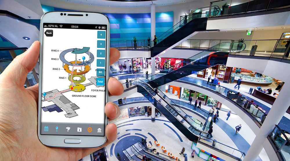
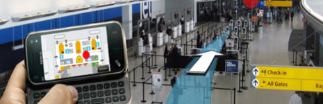
We can image the huge demands for Indoor Positioning System in future. IPS can help people rapidly locate the exits and elevators in a department store. Parents can use IPS to track young kids in a supermarket. A student can use IPS to find where the classmates are. Passengers can use IPS to fast locate the boarding gate An intelligent house can turn on and turn off the lights based on your current position in the house.
In last 10 years, many research institutes and companies have done intensive study and put huge investment in IPS area. Now, several technologies have been considered mature and practical for IPS applications, such as Bluetooth, WiFi, RFID, Zigbee, Broadband and Earth Magnetic Field, etc. The major challenges and difficulties include interference, obstruction and attenuation. The front runners in IPS are Google, Apple and Nokia.
Apple iBeacons
Apple has developed a technology called iBeacons which is Apple’s implementation of Bluetooth Low Energy (BLE) wireless technology. Apple uses iBeacons to provide location based information to iOS based devices, such as phones and tablets. iBeacons is based on BLE (Blutooth Low Energy), a low Bluetooth technique first developed by Nokia in 2001. The purpose of developing BLE was to developing a new Bluetooth standard that is compatible to the standard Bluetooth technique and offers low cost and low energy advantages. In 2004, Nokia released the BLE standard and in 2006, Nokia first registered its Wibree name for BLE technique. The longest range of BLE can reach 150 feet (45 meters). Based on iBeacons technology, we can measure the received signal strength, phase of received signal or reference points for indoor positioning.
![]()
![]()
Nokia HAIP
Nokia has developed an IPS technology based on BLE (Bluetooth Low Energy). It is called HAIP (High Accuracy Indoor Positioning solution. HAIP uses BLE triangular positioning technique and boasts an accuracy of 0.3 meters. In a building that has been installed multiple positioning beacons, you can use your HAIP enabled mobile device to receive the location based information from the nearby beacons. The advantage of HAIP is that it uses 2.4GHz band which is the same as Bluetooth and WiFi signals. Therefore current mobile devices in the market do not need install special antenna and will be fully compatible with the HAIP technology. The users just need download an app to their devices to start using the feature. One of the most important features of HAIP is the low energy consumption. HAIP only consumes 1/30 of the energy that a typical GPS device demands. Contrast to the triangular positioning by GPS, HAIP device only needs one transmitter to locate the position and the HAIP app can simultaneously calculate the angles between the device and the transmitter (beacon). Typically, a beacon can cover an area of 200 square meters. Of course, HAIP can also use multiple beacons to locate the positioning with aid of the app.
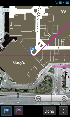
Google Maps Floor Plan
Google first offered limited IPS function in Google Maps for Mobile 6.0. The function was realized by combining GPS signal, WiFi signal, position of cellular base station and blind spots to locate the position. Sometimes we can see only 2 or 3 satellites from indoor and most times we see none of the satellites. The accuracy of this solution is not satisfactory. Therefore, Google released a new app called Google Maps Floor Plan Marker to assist Google IPS users to improve the accuracy of IPS. Based on its experience and reputation in Google Maps , Google continues to collect floor plans of buildings to improve the IPS accuracy. Google also encourages Google users to upload floor plans. Furthermore, Google collects information of GPS, WiFi and Cellular stations and upload the information to the servers for post processing to improve the positioning services.
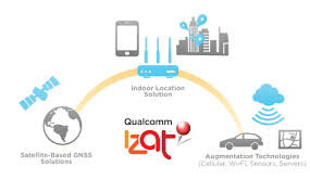
Qualcomm iZAT and Gimbal
Qualcomm iZAT Indoor Location System is part of Gimbal developer platform. IZAT was first developed on Qualcomm’s Snapdragon S4 processor. Qualcomm’s iZAT solution is based on Qualcomm Athero’s 802.11ac and 802.11n access point solutions. The technology employs advanced Wi-Fi based position calculation that improves the accuracy to 3 to 5meters in open or enclosed environment in the enhanced version of iZAT. IZAT also includes other related technologies such as always-on location, geofencing and object recognition. As a developer platform, Android based Snapdragon SDK includes many useful tools and API’s, which provide unique location functions to simplify the development of Snapdragon processor based location applications.
In addition to enhanced location function on mobile devices, iZAT location platform also provides WiFi network clients infrastructure capability for location-aware services.
Qualcomm’s Gimbal developer platform is a location-aware mobile engagement platform that helps people deliver the location-related content, offers and information that consumers want. Being the leading technology in class, Gimbal beacons provide geofencing, secure proximity beacons, location-based messaging, analytics and consumer privacy controls. Retailers can use Gimbal to build their sales systems on Bluetooth network and they can track the customers’ paths in their stores. The developers can develop mobile apps for tracking locations in short ranges based on Gimbal beacons. These apps can display relevant information about a specific location, such as promotions and sales, when the customer gets into the range of a Gimbal beacon.

Photo courtesy to: www.geoawesomeness.com, www.engadget.com, etc.